

Management Strategies When Tropical Weather Approaches (Collins & Edmisten)
go.ncsu.edu/readext?1095690
en Español / em Português
El inglés es el idioma de control de esta página. En la medida en que haya algún conflicto entre la traducción al inglés y la traducción, el inglés prevalece.
Al hacer clic en el enlace de traducción se activa un servicio de traducción gratuito para convertir la página al español. Al igual que con cualquier traducción por Internet, la conversión no es sensible al contexto y puede que no traduzca el texto en su significado original. NC State Extension no garantiza la exactitud del texto traducido. Por favor, tenga en cuenta que algunas aplicaciones y/o servicios pueden no funcionar como se espera cuando se traducen.
Português
Inglês é o idioma de controle desta página. Na medida que haja algum conflito entre o texto original em Inglês e a tradução, o Inglês prevalece.
Ao clicar no link de tradução, um serviço gratuito de tradução será ativado para converter a página para o Português. Como em qualquer tradução pela internet, a conversão não é sensivel ao contexto e pode não ocorrer a tradução para o significado orginal. O serviço de Extensão da Carolina do Norte (NC State Extension) não garante a exatidão do texto traduzido. Por favor, observe que algumas funções ou serviços podem não funcionar como esperado após a tradução.
English
English is the controlling language of this page. To the extent there is any conflict between the English text and the translation, English controls.
Clicking on the translation link activates a free translation service to convert the page to Spanish. As with any Internet translation, the conversion is not context-sensitive and may not translate the text to its original meaning. NC State Extension does not guarantee the accuracy of the translated text. Please note that some applications and/or services may not function as expected when translated.
Collapse ▲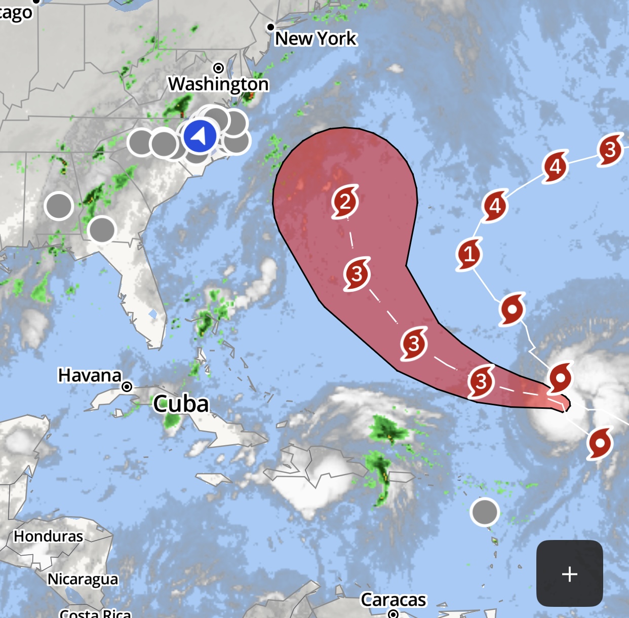
This is our least favorite subject to write about. Hopefully this is a wasted effort. Regardess, there remains quite a bit of uncertainty regarding the likely path of Humberto, and moreso for the yet-to-form Imelda which is only a short distance off-shore. Models have changed quite a bit just today. The lack of uncertainty, and little notices, leaves us scratching our heads regarding what we should do. Your own personal risk tolerance should influence your decisions, but below are some of our general recommendations for potential landfall of tropical weather.
Most areas remain dry, although forecasts are looking more favorable for rain this weekend and early next week. The recent dry weather in most places has noticeably accelerated boll opening, as expected, and most unopened bolls are fairly mature, meaning that they will also likely open relatively quickly unless rains and cool weather slow them down.
We’ve said this more times that we can count……If a tropical storm makes landfall in NC, open bolls are vunerable and closed bolls are protected for the time being. If you have several unopened bolls remaining, DO NOT defoliate in the days leading up to a storm. Most growers are usually concerned about losing time due to saturated ground following a storm. There is no point in being on time when there isnt much left to harvest. Once there is some degree of certainty that tropical weather is likely, it is best to pause defoliation until it passes. If the storm misses us, and hopefully it does, then we may lose a few working days, at worst. If a storm hits us AND there are a meaningful number of closed harvestable bolls remaining, those bolls will be protected for the most part. A slightly cracked boll will likely hardlock and a fully opened boll will likely be lost to weathering.
Below is a fraction of data from a recent research project that our Master’s student, Jeremy Hendricks, just completed.
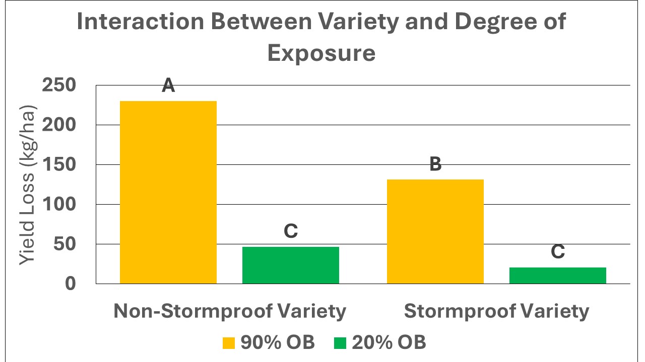
This data illustrates both the value of a stormproof variety, which is less likely to lose as much yield during high winds/rain, and the risk of loss due to high exposure (more bolls opened). Obviously, we cant change varieties at this point, but there is value in stormproofness when tropical events occur, so this is something to consider. Conversely, varieties with a high degree of stormproofness may also be more at risk of hardlocking in years when prolonged wet weather occurs while bolls are opening. There is a tradeoff, but stormproofness, as well as spreading out planting dates, are both ways to mitigate some risks in the Fall.
This chart also illustrates risks of yield loss due to increased exposure (higher proportion of bolls opened when tropical wind/rain occurs. Although the stormproof variety lost less yield than a non-stormproof variety, both varieties lost substantially more yield when more bolls were opened during tropical conditions. This is the one factor we can control at this point.
So again, if you have a meaningful number closed bolls remaining in the field, DO NOT defoliate until these storms pass. We are not behind schedule yet, so risking a few potential lost days of fieldwork is a minor concern right now. The greater concern is the risk of losing noticeably more yield if we defoliate now or for a few more days leading up to a potential tropical weather event. If you have already defoliated and nearly all bolls are open, try to harvest it (if weather allows) before any potential storm arrives